Tuesday, December 2, 2014

Climate Change Impacts in Madagascar


(Apologies in advance for the fact that most of this blog is written about the African region in general and not the island of Madagascar specifically)

On the island of Madagascar marine ecosystems are being highly impacted by climate change. This is a major biological ecosystem being threatened by the changing climate. Key risk factors in the African region are included as follows. There is a major strain on water resources due to droughts. When it does rain it rains heavily and flooding occurs. This makes for poor abilities for crop production.

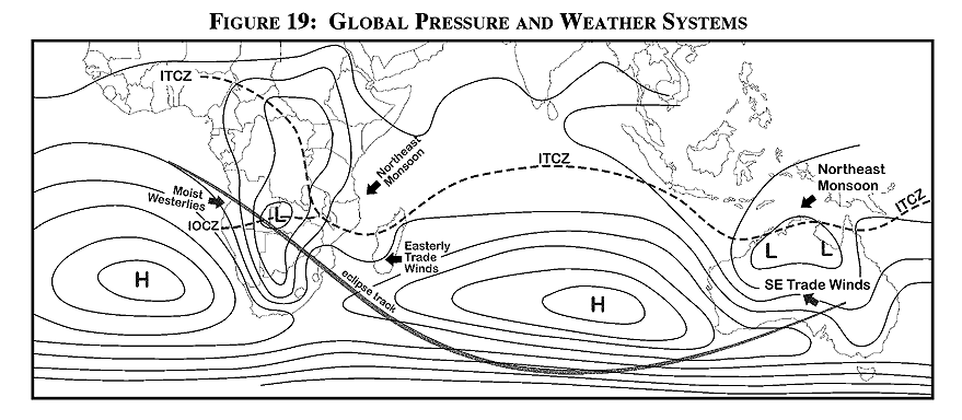
The warm waters in the indian ocean bring heavy, semi-annual, rainfall to the island and the eastern edge of Africa. It is predicted that in the future there will be significant drying and moistening in this african region. It is predicted that at the beginning of the main rain season it will be dryer while the end of the season is predicted to increase in the amount of moisture that is received.  Part of the evidence for this is determined by the moisture in the soil and is accompanied with a variety of simulations. Temperatures are also expected to increase as time goes on.

Above is the top ten countries vulnerable to climate change. As you can see, Madagascar is 10th on the list. 
http://www.nature.com/nclimate/journal/v2/n3/fig_tab/nclimate1423_F1.html


There is undeniable evidence that temperatures are expected to rise as time continues on in the African region. It is easy to see because it has been increasing over the last century. This combined with the fact that a higher rainfall is expected could be detrimental to the region. The ecosystems are already being effected. The warming ocean waters will have a major impact on the coral reefs on the eastern side of the continent. Also, warmer temperatures will increase the chance of drought. With less water availability not only do people suffer but the land and crops suffer too. There have been solutions to problems such as these but they are all short term and won't last forever. As time goes on these outcomes are only predicted to get worse until a long term solution is found. So due to climate change people are in danger of dehydration and malnutrition along with things like band sanitation and poor health care. This things could happen without the climate change but the climate change is basically just multiplying them.

It is clear by just looking at this graph the kind of temperature change that is going on in Madagascar!
http://berkeleyearth.lbl.gov/regions/madagascar


I chose to take a closer look into the impact climate has on agriculture and food security in the African region. Food is a livelihood for people all over the world. It is how we all stay alive and healthy and some even make their income off of their land (crops). It is what makes or breaks a country/continent and without it life can not be sustained so it seems to me that it would be one of the most important things being impacted by climate change. African crops are very vulnerable in the fact that they pose a high reliance on rainfall. It is hard for crops to adapt to the change in temperatures and the shortened rain season. The limited access of water and increase in temperature is also a stressor on those who raise livestock. The amount that is grown and bred for food is also decreasing. The temperature increase in the ocean water will have a negative affect on the coral reefs and the fish inside those reefs. The list of effects that climate change has on agriculture in this area of the world goes on and on but hopefully you have gotten the idea of what is going on in this region.


Sources:

Thursday, November 20, 2014

Severe Weather in Madagascar

TORNADOS
Tornados form in different steps. First a rotating body of air starts do the differences in wind speed at different altitudes, or better known as vertical wind sheer. Then the vertical updraft of a thunderstorm causes that horizontal rotating body of air to turn into a vertical rotating body of air giving you what is called a mesocyclone. This mesocyclone is now located in the center of the thunderstorm cloud and the tornado will come from the bottom of the mesocyclone through the bottom of the cloud. Usually tornados move from southwest to northeast or west to east in the United States because thats the general direction in which t he wind blows through the states. Around 1253 tornadoes occur in the us per year.
http://www.ncdc.noaa.gov/climate-information/extreme-events/us-tornado-climatology
Usually no tornadoes occur in Madagascar due to the fact that the temperature is consistent so there are pretty much never any warm and cold fronts colliding and mixing together.
http://www.worldtravelguide.net/madagascar/weather-climate-geography


As you can see, Madagascar only has some risk in suffering from tornadoes just because severe storms do occur on the island so it technically wouldn't be 100% impossible but just highly unlikely.
Over time tornadoes have been noticeably increasing. I think this had a big reliance on the fact that technology over the last 50 years has improved greatly so when a tornado in the middle of nowhere happens, it is know about due to the instruments that meteorologists use.

HURRICANES
In order for hurricanes to form they need warm ocean temperatures that extend deep into the ocean and corolis (so above 5° N/S). Madagascar does indeed have these things so tropical storms and hurricanes do occur often. Madagascar is located at around 20° S so there is plenty of warm and plenty of corolis. The region near the Indian Ocean and Australia (where Madagascar is near) these Hurricanes are called Cyclones. Off the coast of China and Indonesia they are called Typhoons. The ones in the Atlantic and Eastern Pacific Ocean are the ones we call Hurricanes. I have included a photo below where you can clearly see all three of these regions. In the United States, as you can also see from the photo below, hurricanes follow a "C" shape pattern. They go W then NW then N then start curving NE. This is due to the fact that the trade winds that blow to the W turn in to the westerlies that blow toward the east around that 30° mark which is where they start to curve. Hurricanes, or Cyclones, do occur in Madagascar. Usually around 11-12 named tropical storms hit the US per year.
http://www.aoml.noaa.gov/hrd/tcfaq/E11.html
Think of that then compare that to the 4 or 5 that cross over Madagascar every year. Not as many but you have to remember that the size of Madagascar is not that large. It is also unfortunate that these cyclones have been noticeable getting more intense over the years, parts of the global climate change. If you would like to learn more about Madagascar, it's climate change, and the hurricanes that affect the island the link below leads to a very informative powerpoint.
http://siteresources.worldbank.org/EXTUNITFESSD/Resources/1633787-1322594494226/Mamy-Razakanaivo.pdf


Other Sources Used:

Tuesday, November 4, 2014

"Daily Weather In Madagascar

By using the www.wunderground.com website I gathered the following information on Madagascar's weather......

For the following three days I found out the days high temperature, low temperature, precipitation, average pressure, and average wind speed of Madagascar's capitol, Antananarivo. On Tuesday, November 4 the high temperature is expected to be 81 and a low temperature of 60. There is a 3% chance of precipitation around noon and 11% chance around 3pm. On Wednesday, November 5, the high is expected to be 83 and the low to be 60. There is a 0% chance of precipitation both at noon and 3pm. On Thursday, November 6, the high temperature is expected to be 83 and the low to be 61. There is a 9% chance of precipitation at noon but by 3pm there is a 64% chance of rain. The average pressure over the three days is around 30.6 and decreases just a slight amount over the few days. The average wind speed over the days is around 6.4mph and also decreases as the few days pass on.


The map below is also from wunderground.com

 As you can see there a couple large cloud clusters to the north of and the east of Antananarivo. They are mostly low clouds (grey and blue) but a large yellow and orange cloud cluster means it is higher than the rest of the clouds in the image. Antananarivo is marked by the red marker. At the time that the screen shot was taken it was 74°F. No kinds of precipitation are shown so it must not currently be raining anywhere in Madagascar. There is a national forest as you can see to the east of the city and a vast area of wide open forests  and park areas to the west. Down the center you can see all the texture looking marks that signify the mountains that are on the island.


The following information was gotten from www.intellicast.com.


The map below is of southern Africa which includes Madagascar on the right side of the image. There looks to be a low front located just on the west side of the island. It is hard to tell because of the small map in the corner but it looks to be around 1016mb. There is also three different fronts in the image. A cold front, which is the blue line with triangles, a warm front which is a red line with spheres, and a stationary front which is both red and blue, triangles and spheres.
 On this image you can see the whole Africans area and the pressures it consists of. You can see that warm front, cold front, and stationary front on the bottom of the image. There aren't any more fronts except for the one you can see at the very top of the picture. There are also no more highs or lows on the continent that you cant see in the image above. 

Tuesday, October 28, 2014

Global and Local Winds in Madagascar!


Madagascar's latitude is around 18° S and 47° E. This puts the country in the southern hemisphere in the Hadley cell. In this wind belt are the trade winds or the tropical easterlies. The wind blows from the east. Madagascar is in the middle of the Hadley cell so it is not under a main pressure belt but the southern tip of the island is around 25° S so it comes right up to the area where subtropical highs are located. 25° S(N) are also where the Horse latitudes start so the island comes right up to those also so winds weaken in the very southern part of the island compared to the north.

Since Madagascar is in the Hadley cell it should expect to have a warmer climate since it is closer to the equator. Also, since the winds blow from the east the windward side of the island (the eastern side of Madagascar) is a lot wetter (more rain) than the leeward side (western side) where deserts are more commonly found. The pressure is lower in this cell due to excessive heating.
http://eclipse.gsfc.nasa.gov/SEmono/TSE2002/TSE2002gif/TP2002-Fig19s.gif


Some breeze/winds that are associated with mountains include Eddies, valley breeze, mountain breeze, katabatic winds, and chinooks. Madagascar does indeed have a mountain range that is quite similar to those here on O'ahu. You will mostly likely find the valley and mountain breezes in Madagascar. Since Madagascar is also an island there is nothing but a coastline surrounding it. Sea and land breezes and monsoons are both likely to happen on a coastline around this area of the world. Both are experience in Madagascar. 


Sources:
My textbook

Thursday, October 9, 2014

Typical Weather and Tourism in Madagascar


During the month of June is when the winter solstice occurs in Madagascar. This year it will be on Saturday, June 21. The average maximum temperature is usually around 76. The average minimum temperature reaches around 59. The precipitation for June is low staying around 2.5 inches of rain.

During the month of December the summer solstice occurs. This year it will fall on Monday, December 22. The average maximum temperature is usually around 84 in December. The average minimum temperature is around 68. The precipitation is usually about 8-9inches of rain.

During the month of September the spring equinox occurs. This year it will fall on Tuesday, September 23. The average maximum temperature for that month is around 78 while the minimum temperature is around 60. There is low precipitation in September, seeing around 2in of rain during that month.

During the month of March the autumnal equinox occurs. This year it will fall on Thursday, March 20th. The maximum temperature for this month is around 83. The minimum temperature falls around 68. Precipitation is heavy in this month as well seeing around 9 inches of rain in September.

If I was advising someone to visit Madagascar I would recommend they visit during the spring (September-December). During this time it is great for seeing animals, since it is breeding season, most of the animals that live in Madagascar are active during this time. Exploring the forests and bird watching and lemur watching is recommended. There are no huge weather hazards during this time. While I would guess it's always possible for a hurricane to hit, the spring in Madagascar has very low precipitation so cyclone and hurricanes aren't near as likely to happen as they are during the winter and fall. While it may be less wet during this time it is important to keep in mind it is very humidity in most all locations in Madagascar during all times of the year. It sometimes reaches above 90% humidity! The great thing about this time is that it won't be too hot or too cold. It only gets to about low 80s at the shore and low as the mid 70s in the higher altitudes. The perfect temperatures for exploring!

http://www.safari.co.uk/madagascar/

I can't share just one photo!


http://www.rainbowtours.co.uk/blog/nature-based-tourism-part-1-madagascar/a-stream-in-the-primary-rainforest-of-ranomafana-national-park-eastern-madagascar/

Okay ONE more....!

http://upload.wikimedia.org/wikipedia/commons/b/bd/Spiny_Forest_Ifaty_Madagascar.jpg

From the beaches, to the mountains, then over the rain forests, then deserts Madagascar is everything wrapped into one island, ready to be explored by all adventure seekers!


Information found at:

Thursday, October 2, 2014

Temperature controls in the city of --- in Madagascar

On this post today I will be discussing the climate of Madagascar's capitol, Antananarivo. I will go over its current temperature averages, the things that impact those averages, then end with a look into what could be in store for the future climate of this city.


Antananarivo is in located on the eastern slope of the mountains close to the center of the country. Its latitude and longitude were around 18° 55' S and 47° 31' E. The warmest month of the year is usually January or February, both with an average of 69°F. The coolest month of the year is July, with an average temperature of 57°F. This gives Antananarivo the temperature range of 8°F which is not much at all. Part of the reason for this warmer climate with such a small range is because it is rather close to the equator. Also, what I realized about the city is that it really isn't not affected by any of the temperature controls that we had discussed in my meteorology class (sorry for the double negative). It is close to the equator so it doesn't have much temperature change during the year. It is on a mountain at an elevation of 4,186ft, so it stays cooler that what it would at the shore. Also since it is up in the mountains it tends to be quite cloudier during the day which also helps to keep it cooler. It is on an island and on the side of the island that the wind runs into so the warmer air that sweeps SE into the island from the ocean is blown up into the city (thus being one of the causes of the clouds I brought up just before this). Since Antananarivo is affected by so much there are many things that could occur to cause a fluctuation in the city. In fact, when I was researching it happens that things are currently happening there that are causing quite the stir, and not just in the city but the whole country. One of the things being the oceans and their temperature and climate. Madagascar is know for its beautiful reefs that overflow with sea life and if those are taken away by climate change the country would be headed for not such a great place. It has also been getting rainier and rainier each year. This is not only causing flooding but providing the country to be the perfect habitat for locusts. Literally 500 billion locust are thought to be on the island right now and could take down nearly 60% of Madagascar's rice crop! Rice is the staple ingredient in the countries cuisine. When looking to the future for Madagascar I can only hope there will be brightness... I have included a video of the locust in Antananarivo for your view pleasures... I could never even imagine it.